How to get to the Bunkers del Carmel?
The Bunkers del Carmel are located at the top of Turó de la Rovira, standing at an elevation of 262 meters—about 250 meters above the city of Barcelona. You should be prepared to tackle this height difference. Additionally, the bunkers are not located in the immediate city center near the usual tourist hotspots; they are situated in the northern part of the city, some distance away. While public transport is available, there is no direct high-speed connection from the Old Town, so you will likely need to transfer. The final stretch must be covered on foot. For most visitors, it is a strenuous climb, but the impressive panoramic view of Barcelona makes it well worth the effort.
You can reach Turó de la Rovira by bus or metro. Taking the bus is often the most convenient option, as it drops you off closer to the summit, while the metro stations require a longer walk. The site has a total of six entrance gates strategically distributed around the perimeter, making it accessible from all directions. Here are the details for reaching the site by bus and train:
Reaching the Bunkers del Carmel by Bus
Taking the bus is the best option for reaching the Bunkers del Carmel directly. Two main lines serve the area:
- Line 92: Get off at the Ctra. Carmel – Mühlberg stop, which is situated in the immediate vicinity of the site.
- Line 119: Get off at the Marià Lavèrnia stop. This is the terminal stop for this line. You can catch this bus starting from the Penitents (L3) metro station.
After exiting the bus, you will need to cover the remaining distance on foot. It only takes a couple of minutes to reach the Bunkers. From the Marià Lavèrnia stop, you can already see the Bunkers ahead of you.
Reaching the Bunkers del Carmel by Metro
Unfortunately, there is no metro station directly at the Bunkers del Carmel. The closest options are:
- Line 4 (L4): Take the metro to the Alfons X station. From there, it is approximately a 25-minute walk uphill to the Bunkers.
- Line 5 (L5): Take the L5 to El Carmel (near Camí dels Àngels). From there, you can transfer to bus line 119 and ride it to the terminal stop.
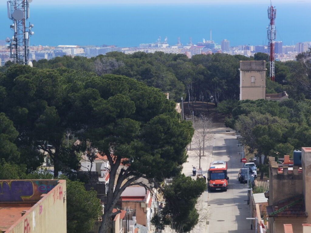
Alternatively, you can use the Vallcarca or Penitents stations. However, the route from Alfons X is often preferred. From Alfons X, you walk through the Parc de les Aigües, then through the neighborhood to Plaça de la Font de la Castellana in Can Baró. The view from here is already fantastic. Can Baró was formerly a quarry, where stone was extracted to build local houses. Today, the area features a large parking space and a trail along the rocks that leads up to the Bunkers. The path climbs through several levels. Keep an eye out for the houses at the top—two of them especially reminded me of the magnificent works of Gaudí. If you choose the metro, you have a great opportunity to explore the El Carmel district or visit Parc del Carmel, which is situated between the Bunkers and Park Güell.
For your orientation, the direction of the destination: Carrer de Marià Labèrnia, s/n, 08032 Barcelona. This is the Link to the Google map.
Pro Tip: Make the Most of Your Trip
A great way to spend your day is to combine the Bunkers with nearby sights. Park Güell is only about a 20-minute stroll from here. If you’re up for a slightly longer walk or a quick ride, the famous Hospital de la Santa Creu i Sant Pau is just 2 km away.
My personal conclusion
If you ask me, the metro is the way to go. The hike up from the station is a huge part of what makes the Bunkers del Carmel so special. I’d skip the bus every time—it’s too fast and you miss the real vibe of the streets. Taking the bus feels like you’re just ticking a box on a tourist bucket list. If you want a genuine experience instead of just the easy route, you’ve got to earn the view on foot.
Related Links:
- all the information about the Bunkers del Carmel
- note: the Bunkers of Carmel opening hours
- all the information about admission & tickets
Common questions for getting to the bunkers del Carmel
If you value comfort and want to avoid the most strenuous part of the journey, the bus is the best choice. If you’re starting from a lower elevation, the combination of the metro (L4 to Guinardó) and the city’s escalators can make the climb easier.
Bus lines 119, 24, 92, and V19 stop closest to the summit. While you still have to hike the final, steep section by bus, it’s the shortest route of all the options. Line 119 is a small local bus that goes particularly close to the top.
The nearest metro stations (e.g., El Carmel, L5 or Guinardó, L4 ) require a very steep climb of about 20 to 45 minutes (depending on your starting point and fitness level). This is the best option if you want to hike up to the bunker or also visit the El Carmel neighborhood.